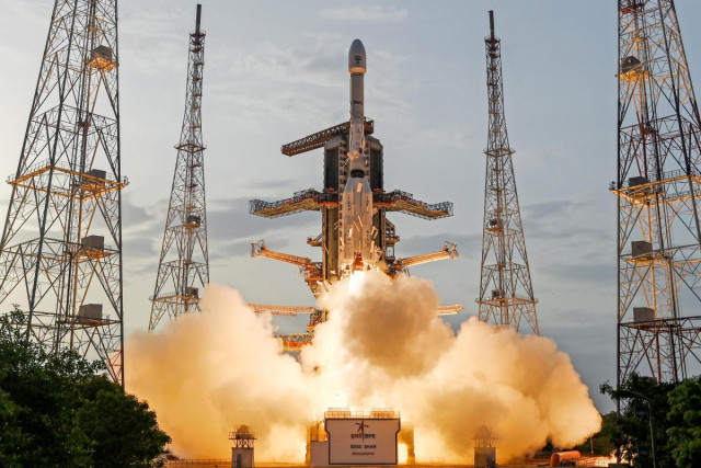
A powerful new radar satellite, developed in collaboration between the United States and India, was launched on Wednesday.
It is intended to monitor subtle changes in the Earth's land and ice surfaces, aiding in the prediction of both natural and human-induced hazards.
Known as NISAR (NASA-ISRO Synthetic Aperture Radar), this pickup truck-sized spacecraft lifted off around 5:40 pm (1210 GMT) from the Satish Dhawan Space Centre located on India's southeastern coast, utilizing an ISRO Geosynchronous Satellite Launch Vehicle rocket.
A livestream of the launch showed thrilled schoolchildren gathered to witness the event, as mission teams celebrated with cheers and hugs.
This mission, highly anticipated by scientists, has been praised by US President Donald Trump and Indian Prime Minister Narendra Modi as a significant step in strengthening cooperation between the two nations.
"Congratulations India!" stated Dr. Jitendra Singh, India’s Minister of Science and Technology, on X, describing the mission as a "game changer."
"Our planet's surface experiences constant and significant change," said Karen St Germain, director of NASA’s Earth Science division, to reporters before the launch.
"Some changes occur gradually, while others happen suddenly. Some variations are large, and others are more subtle."
The satellite can detect minute shifts in the vertical movement of the Earth's surface — as small as one centimeter (0.4 inches) — enabling scientists to identify early indicators of natural disasters and human-induced crises, including earthquakes, landslides, and aging infrastructure like dams and bridges.
St Germain described NISAR as "the most advanced radar we've ever constructed," noting it will monitor land subsidence, swelling, deformation, and melting ice sheets in regions such as Greenland and Antarctica, along with wildfires.
India specifically aims to investigate its coastal and nearby ocean regions by observing annual alterations in the configuration of the sea floor near river deltas and tracking the changes in shorelines.
The gathered data will facilitate agricultural policy guidance by mapping crop growth, assessing plant health, and monitoring soil moisture levels. In the upcoming weeks, the spacecraft will enter an approximately 90-day commissioning phase during which it will deploy its 39-foot (12-meter) radar antenna reflector.
Once operational, NISAR will capture almost all of Earth's land and ice every 12 days from an altitude of 464 miles (747 kilometers), orbiting near the poles rather than the equator.
As it travels, the satellite will continuously emit microwaves and receive echoes from the Earth's surface.
The spacecraft's motion causes distortion in the returning signals, but computer processing will reconstruct these signals to create high-resolution, detailed images.
Achieving comparable results with conventional radar would require an impractically expansive 12-mile-wide dish. NISAR will function on two radar frequencies: L-band and S-band.
The L-band frequency is optimal for detecting taller vegetation such as trees, whereas the S-band offers more precise measurements for shorter plants like bushes and shrubs. NASA’s Jet Propulsion Laboratory and India’s ISRO divided the development tasks, with each organization crafting components on opposite ends of the globe before assembling and testing the spacecraft at ISRO’s Satellite Integration & Testing Establishment in Bengaluru, India. NASA’s financial input was just under $1.2 billion, while ISRO contributed roughly $90 million.
India’s space program has achieved significant advancements in recent years, including the successful placement of a probe into Mars orbit in 2014 and the landing of a rover on the Moon in 2023.
Shubhanshu Shukla, a test pilot with the Indian Air Force, has recently become the second Indian to travel to space and the first to reach the International Space Station, marking a crucial milestone for India’s indigenous crewed mission planned for 2027 under the Gaganyaan ("sky craft") program.


